“I saw the termination dust in September,” said my colleague, nodding out the office window toward the Chugach Range. When I raised my eyebrows, he added “That’s what Alaskans call that first sprinkle of snow on the mountaintops, because it means summer is coming to an end. I’ve never seen it that early before.” I filed the phrase away for the title of a future dystopian novel and marveled at the distant peaks. Although I’d been in Alaska for almost two months, I’d rarely seen its horizons through a veil of consistent grey weather.
Like an unhappy cartoon character, I seem to have a personal thundercloud tailing me. Moving to Australia shortly after the Black Summer bushfires in 2020, I experienced three successive La Niña events. Summer mercury never hit its typical blistering highs, and floods devastated tropical Queensland. Two months ago, my job relocated me to Alaska. The rain followed. Locals bemoaned the uncharacteristically cool temperatures. Constant drizzle spoiled my ambitions for late-summer wildlife photography. Now, according to my coworkers (and their whiteboard predicting Anchorage’s first snowfall), winter might creep in ahead of schedule.
Yet in June, the National Oceanic and Atmospheric Administration (NOAA) declared El Niño conditions, which usually implies warmer winters for Alaska. What’s going on with these weather patterns? Could climate change play a role? My initial queries turned up a lot of equivocal articles that claimed no clear links had been established. Unsatisfied, I delved into scientific studies and discovered some surprising conclusions. Before we explore them, let’s review how this complex weather pattern works.
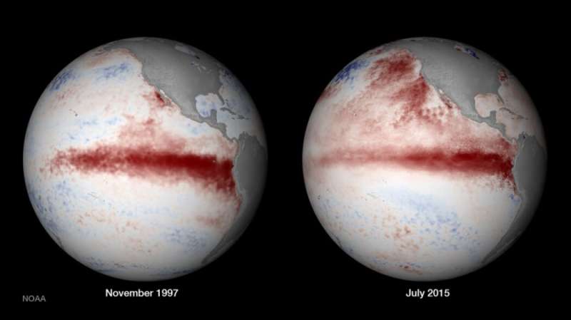
Typically, trade winds push warm surface ocean water westwards across the Pacific Ocean, from South America towards Australia. Cold water wells up to replace it. The resultant temperature disparity reinforces the wind pattern. Warm water also heats the Western Pacific air, creating its rainy tropical biomes. Every two to seven years, however, ocean temperatures remain warmer than normal for an extended time. The trade winds weaken, and warm water accumulates on the eastern side of the Pacific. Wet weather reigns from California to Chile, while arid climates like Australia and India may suffer drought. More hurricanes form in the Pacific. Since it occurs around December when ocean temperatures peak, this phenomenon became known as El Niño (the Spanish term for the Christ Child).
The year after El Niño often over-corrects with an intensification of the normal pattern, dubbed La Niña. Oceania and parts of the Amazon experience wetter conditions, while the southern United States dries out. This duet, called the El Niño Southern Oscillation (ENSO), can wreak havoc on ecosystems with destructive storms, heat waves, and other extreme weather events. But are they really getting more frequent or severe? This is a tricky question to answer. Reliable records of El Niño events only began in the early 20th century. Without clear data on what these patterns looked like before we started spewing greenhouse gasses into the atmosphere, it’s difficult to judge the current state.
Climate scientist Kim Cobb and her colleagues found new pieces to that puzzle in 2018. They extracted cores from fossilized corals on small Pacific islands, each representing a period of 20-80 years for a timeline spanning 7,000 years. Much like tree rings, the cores revealed climate conditions during the organism’s lifetime. A particular oxygen isotope occurred in lower ratios often during warm, rainy El Niño periods and higher rations during cooler, drier La Niñas. These marine biographies indicated that El Niño may get stronger as carbon dioxide levels in the atmosphere increase. The team calculated industrial age ENSO swings to be 25% stronger than in the pre-industrial records. “What we’re seeing in the last 50 years is outside any natural variability. It leaps off the baseline,” said Cobb. “Actually, we even see this for the entire period of the industrial age.”
A 2023 study extrapolated the ENSO data set using computers rather than corals. Researchers compared simulations of Earth’s climate system between 1901-1960 and 1961-2020. Results showed that since 1960, strong ENSO events occurred more frequently than average, contributing to extreme weather around the world. When examined against simulations of pre-industrial CO2 levels, the amplification since 1960 became even more pronounced, further evidence that carbon emissions are enhancing ENSO effects.
Not only are ENSO events getting stronger, they’re changing location. Cluster analysis published in 2019 found that since 1901, El Niño’s onset has shifted from the eastern to the western Pacific, where air and ocean temperatures are warmer. Projections indicated that higher temperatures would likely increase both the frequency and intensity of El Niño events. Additionally, the study found that extreme El Niño events have occurred more often since the 1970s. The researchers concluded that “if the currently observed background changes continue under future anthropogenic forcing, more frequent strong El Niño events are anticipated.”
Studies like these make a strong argument that anthropogenic climate change is amplifying ENSO, and the potential devastation it brings. Even if climate change doesn’t have a direct influence, ENSO may be collateral damage. For example, research published in May 2023 concluded that the rare triple La Niña I experienced Down Under may have resulted from the drought-driven bushfires. How? Atmospheric conditions in the south-eastern Pacific allow smoke particles to interact with water droplets, brightening the clouds. Thicker, more reflective clouds bounce more sunlight away from Earth while shading the sea below. This cools the seawater and precipitates La Niña conditions. Black Summer released so many particles that it likely triggered a triple play, an insidious form of “termination dust” that smothered Australian summers for three years.
Could the Canadian wildfires create similar effects in the Pacific Northwest? I wouldn’t mind an epic winter: I haven’t seen an icicle in three years, and my northern soul longs for snow. Or will the pending El Niño assert itself as December approaches? Being a newcomer to this environment, I can’t offer any anecdotal forecasts. Recent investigations into ENSO, however, indicate the weather may only get wilder. Maybe it’s not a personal rain cloud following me across the globe, but the inescapable influence of climate change.
